Regional Groundwater Monitoring
As required by SB 4 (Pavley, 2013) and detailed in the Model Criteria for Groundwater Monitoring in areas of Oil and Gas Well Stimulation (Model Criteria), State Water Board is to implement a Regional Monitoring Program in order to protect all waters designated for any beneficial use, while prioritizing the monitoring of groundwater that is or has the potential to be a source of drinking water.
Factors considered for the Regional Monitoring Program include well stimulation treatments, among other oil and gas activities that have the potential to contaminate groundwater, such as an oil and gas well failure or breach. Fluids produced or introduced in the well stimulation process including, but not limited to, produced water ponds and Underground Injection Control (UIC) wells are also examined in the Regional Monitoring Program. The United States Geological Survey (USGS) is the technical lead for the Regional Monitoring Program. A letter between the USGS and State Water Resources, dated January 22, 2018 details USGS objectives, sample collection and analysis protocols, quality- assurance procedures, approaches, and reporting procedures used for the Regional Monitoring Program.
More information on the Regional Monitoring Program can be found on the USGS's California Oil, Gas, and Groundwater Monitoring Program website.
Regional Monitoring Program Resources
Reports
Everett at al., 2023 "Multiple-well monitoring site adjacent to the Elk Hills Oil Field, Kern County, California: U.S. Geological Survey Open-File Report 2023-1073"
Everett et al., 2023 “Multiple-well monitoring site within the Poso Creek Oil Field, Kern County, California: U.S. Geological Survey Open-File Report 2023-1047, 11 p.”
Stanton et al., 2023. “Groundwater quality near the Montebello Oil Field, Los Angeles County, California: U.S. Geological Survey Scientific Investigations Report 2022–5128, 80 p.”
Zamudio et al., 2022. “Airborne electromagnetic survey results near the Poso Creek oil field, San Joaquin Valley, California, fall 2016: U.S. Geological Survey Data Report 1155”
Everett et al., 2020. “Multiple-well monitoring site adjacent to the North and South Belridge Oil Fields, Kern County, California: U.S. Geological Survey Open-File Report 2020-1116”
Everett et al., 2020. “Multiple-Well Monitoring Site Adjacent to the Lost Hills Oil Field, Kern County, California”
Metzger and Landon, 2018. “Preliminary groundwater salinity mapping near selected oil fields using historical water-sample data, central and southern California. Scientific Investigations Report 2018-5082”
McMahon et al.,2016. “Preliminary results from exploratory sampling of wells for the California oil, gas, and groundwater program, 2014–15, Open-File Report 2016-1100”
Journal Articles
Hansen et al., 2023 “Spectral characterization of dissolved organic matter in groundwater to assess mixing with oil-field water near selected oil fields, southern California
McMahon et al., 2023 “Fluid migration pathways to groundwater in mature oil fields: Exploring the roles of water injection/production and oil-well integrity in California, USA"
- Please see the article summary for key findings from the study.
Flowers et el., 2022 “Geologic controls on groundwater salinity reversal in North Coles Levee Oil Field, southern San Joaquin Valley, California, USA”
Anders et al., 2022 “Occurrence of water and thermogenic gas from oil-bearing formations in groundwater near the Orcutt Oil Field, California, USA"
- Please see the article summary for key findings from the study.
Gillespie et al., 2022 “Mapping aquifer salinity gradients and effects of oil field produced water disposal using geophysical logs: Elk Hills, Buena Vista, and Coles Levee Oil Fields, San Joaquin Valley, California”
- Please see the article summary for key findings from the study.
Terry et al., 2021 “Geostatistical Mapping of Salinity Conditioned on Borehole Logs, Montebello Oil Field, California”
Tyne et al., 2021 “Investigating the effect of enhanced oil recovery on the noble gas signature of casing gases and produced waters from selected California oil fields”
Stephens et al., 2021 “Stratigraphic and structural controls on groundwater salinity variations in the Poso Creek Oil Field, Kern County, California, USA”
- Please see the article summary for key findings from the study.
Karolyte et al., 2021 “Noble gas signatures constrain oil-field water as the carrier phase of hydrocarbons occurring in shallow aquifers in the San Joaquin Basin, USA”
McMahon et al., 2021“Relative risk of groundwater-quality degradation near California (USA) oil fields estimated from 3H, 14C, and 4He“
Rosecrans et al., 2021 “Groundwater Quality of Aquifers Overlying the Oxnard Oil Field, Ventura County, California”
- Please see the article summary for key findings from the study.
Ball et al., 2020. “Probabilistic categorical groundwater salinity mapping from airborne electromagnetic data adjacent to California's Lost Hills and Belridge oil fields”
Gillespie et al., 2019. “Groundwater salinity and the effects of produced water disposal in the Lost Hills–Belridge oil fields, Kern County, California”
McMahon et al., 2019. “Occurrence and Sources of Radium in Groundwater Associated with Oil Fields in the Southern San Joaquin Valley, California”
Wright et al., 2019. “Groundwater quality of a public supply aquifer in proximity to oil development, Fruitvale oil field, Bakersfield, California”
McMahon et al., 2018. “Regional patterns in the geochemistry of oil-field water, southern San Joaquin Valley, California, USA”
Stephens et al., 2019. “Groundwater salinity mapping using geophysical log analysis within the Fruitvale and Rosedale Ranch oil fields, Kern County, California, USA”
Barry et al., 2018. “Tracing enhanced oil recovery signatures in casing gases from the Lost Hills oil field using noble gases.” The full article is available upon request from USGS via Matt Landon at landon@usgs.gov.
Kulongoski et al., 2018. “Origin of methane and sources of high concentrations in Los Angeles Groundwater” The full article is available upon request from USGS via Matt Landon at landon@usgs.gov.
Data Releases
McMahon et al., 2023 "Oil well annular cement and casing damage data in mature oil fields undergoing hydraulic fracturing, South Belridge and Lost Hills Oil Fields, California”
Stephens et al., 2023 "Groundwater elevation data and models in and around select California oil fields"
Seitz et al., 2023 "Produced water volatile organic compound data collected from eight oil fields, 2016-2020, California"
Metzger at al., 2023 "Historical groundwater chemistry data compiled for the Poso Creek Oil Field and vicinity, Kern County, California"
Shimabukuro et al., 2023 "Idle well fluid measurements for oil and gas wells in California"
Metzger et al., 2022 "Historical produced water chemistry data compiled for the Santa Maria Valley Oil Field, Santa Barbara County, California"
Rodriguez et al., 2022 "Water chemistry data for samples collected at groundwater sites in the Montebello Oil Field study area, September 2014–October 2018, Los Angeles County, California"
Davis et al., 2022 "Produced-water disposal at percolation and evaporation ponds in and near oil fields in the southwestern San Joaquin Valley, California"
Bloss et al., 2022 "Ground-based transient electromagnetic data and resistivity models at selected sites of the California Central Coast and San Joaquin Valley 2019"
Metzger et al., 2022 "Historical groundwater and produced water chemistry data compiled for the Placerita and Newhall Oil Fields, Los Angeles County, southern California"
Flowers et al., 2022 “Geophysical and geological data for select petroleum wells in North Coles Levee Oil Field, Kern County, California”
Zamudio et al., 2022 “Airborne electromagnetic and magnetic survey data, southeastern San Joaquin Valley near Cawelo, California, 2016”
Stephens et al., 2022 "Geophysical, geological, hydrological, and geochemical data for aquifer salinity mapping in the Elk Hills, Buena Vista, and Coles Levee Oil Fields, Kern County, California”
Terry et al., 2021 “Data used to estimate groundwater salinity above the Montebello Oil Field (California, USA)”
Gans et al., 2021 "Historical Produced Water Chemistry Data Compiled for the North Coles Levee Oilfield, Kern County, California"
Stephens et al., 2021 “Geochemical, geological, and geophysical data for wells in the Poso Creek Oil Field area, Kern County, California (ver. 2.0, September 2021)”
Seitz et al., 2021 “Produced water chemistry data collected from the Orcutt oil field, 2018, Santa Barbara County, California
McCarlson et al., 2021 “Water chemistry data for samples collected at groundwater sites near the Orcutt Oil Field, September 2017–March 2018, Santa Barbara County, California”
Metzger et al., 2021, "Historical groundwater and produced water chemistry data compiled for the San Ardo Oil Field and vicinity, Monterey County, central California”
Metzger et al., 2021 “Historical produced water chemistry data compiled for the Orcutt and Oxnard oil fields, Santa Barbara and Ventura Counties, southern California”
Rosecrans, et al., 2021, “Water chemistry data for samples collected at groundwater sites near the Oxnard oil field, June 2017–August 2017, Ventura County, California”
Stephens, et al., 2021, “Mud logs from the Oxnard Oil Field, Ventura County, California”
Stephens, et al., 2021, “Fluid levels in the Oxnard Oil Field, Ventura County, California”
Everett et al., 2020. “Aquifer test data for the Belridge multiple-well monitoring site (BWSD), Kern County, California”
Metzger et al., 2020. "Inorganic chemistry data for groundwater wells near selected oil fields in the southwestern San Joaquin Valley, central California”
Metzger et al., 2020. “Historical produced water chemistry data compiled for selected oil fields in Los Angeles and Orange Counties, southern California”
Metzger and Herrera, 2020. “Historical produced water chemistry data compiled for the Orcutt and Oxnard oil fields, Santa Babara and Ventura Counties, southern California”
Ball and Davis, 2020. “Supporting groundwater salinity data used for salinity mapping adjacent to the Lost Hills and Belridge Oil Fields, Kern County, California”
Ball, L.B. 2020. “Airborne electromagnetic and magnetic survey data, San Joaquin Valley near Lost Hills, California, October 2016” (02/24/2020)
Everett et al., 2020. “Aquifer test data for multiple-well monitoring site (LHSP), Kern County, California”
Gans et al., 2019. "Historical Produced Water Chemistry Data Complied for the Elk Hills Oilfield, Kern County, California"
Gillepsie et al., 2019. “Geological, geochemical, and geophysical data from the Lost Hills and Belridge oil fields: U.S. Geological Survey data release”
Everett et al., 2019. “Geochemical and geophysical data for selected wells in and surrounding the South Cuyama oil and gas field”
Gans et al., 2019. “Historical produced water chemistry data compiled for the Lost Hills and North and South Belridge Oilfields, Kern County, California”
Haugen et al., 2018. "Geophysical and geochemical data for salinity mapping in the Midway-Sunset oil field area"
Stephens et al., 2018“Geochemical, geological, and geophysical data for wells in the Poso Creek oil and gas field, Kern County, California”
McCarlson et al., 2018. "Water chemistry data for samples collected at groundwater sites near the Fruitvale oil field, September 2016–February 2017, Kern County, California"
Stephens et al., 2018“Geochemical and geophysical data for wells in the Fruitvale and Rosedale Ranch oil and gas fields, Kern County, California, USA”
Davis et al., 2018. "Groundwater and surface water chemistry results for samples collected near the Lost Hills and North and South Belridge oil fields, Kern County, California"
Metzger et al., 2018. "Water and petroleum well data used for preliminary regional groundwater salinity mapping near selected oil fields in central and southern California"
Davis et al., 2018. “Data Analyzed for the Preliminary Prioritization of California Oil and Gas Fields for Regional Groundwater Monitoring”
Gannon et al., 2018 “Produced water chemistry data for the Lost Hills, Fruitvale, and North and South Belridge study areas, Southern San Joaquin Valley, California”
Gans et al., 2018. “Historical produced water chemistry data compiled for the Fruitvale Oilfield, Kern County, California”
Kulongoski et al., 2016. “Produced water chemistry data for samples from four petroleum wells, Southern San Joaquin Valley, California 2014”
USGS oil and gas regional monitoring activities are presented at our public stakeholder meetings. Recordings of recent meetings are below:
- Aug 12, 2020 Public Stakeholder Meeting
- Please refer to the Meeting Summary for an overview of the studies presented. To view the question and answer period of the meeting, please refer to 1:22:18 on the video recording.
- February 25, 2019 Public Stakeholder Meeting
- June 12, 2018 Public Stakeholder Meeting
Stay Informed
Subscribe to the Oil and Gas Groundwater Monitoring (SB4) email list!
Check your email account for a confirmation email to complete your subscription.
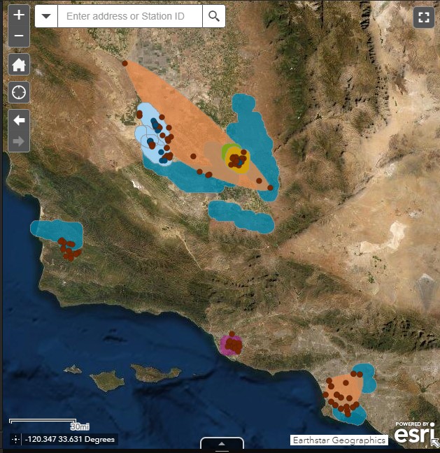
Regional Monitoring Program Mapping Tool
Visit the Regional Groundwater Monitoring Program online map to spatially view study areas and access available publications for each study area.